Aurora (province)
| Aurora | |||
|---|---|---|---|
| — Province — | |||
|
|||
 |
|||
| Coordinates: | |||
| Country | |||
| Region | Central Luzon (Region III) | ||
| Founded | August 13, 1979 † | ||
| Capital | Baler | ||
| Government | |||
| - Governor | Bellaflor Angara-Castillo (LDP) | ||
| Area | |||
| - Total | 3,147.32 km2 (1,215.2 sq mi) | ||
| Area rank | 44th out of 80 | ||
| Population (2007) | |||
| - Total | 187,802 | ||
| - Rank | 69th out of 80 | ||
| - Density | 59.7/km2 (154.5/sq mi) | ||
| - Density rank | 75th out of 80 | ||
| Divisions | |||
| - Independent cities | 0 | ||
| - Component cities | 0 | ||
| - Municipalities | 8 | ||
| - Barangays | 151 | ||
| - Districts | Lone district of Aurora | ||
| Time zone | PHT (UTC+8) | ||
| ZIP Code | |||
| Spoken languages | Tagalog, Ilocano, Kapampangan | ||
| † Became a sub-province of Quezon in 1951. | |||
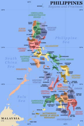
Aurora is a province of the Philippines located in the Central Luzon region. Its capital is Baler and borders, clockwise from the south, the provinces of Quezon, Bulacan, Nueva Ecija, Nueva Vizcaya, Quirino, and Isabela. To the east of Aurora is the Philippine Sea.
Before 1979, Aurora was part of the province of Quezon. Aurora was, in fact, named after Aurora A. Quezon, the wife of Pres. Manuel L. Quezon, the president of the Philippine Commonwealth, after whom the mother province was named.
Contents |
People and culture
The majority of the people of Aurora province are lowland Christians, particularly Tagalog in municipalities south of Baler, the capital, Ilocano in municipalities north of Baler, and some Kapampangan in the capital.
There are also pockets of Negritos, called Dumagats. Most Dumagats are living in the hillsides or mountains. They are believed to have result from a fusion of Austronesian and Melanesian ancestries, and survive from fishing and hunting. There are three kinds of Dumagats in Aurora province, the Umiray Dumagat, Casiguran Dumagat, and the Palanan Dumagat. All three subgroupings have the Bible translated into their languages.
Economy
Corn crops, rice and other major agricultural crops are grown in Aurora.
Geography
Political
Aurora is subdivided into 8 municipalities.
Municipalities
|
|
Physical
History
In 1572, the Spanish explorer Juan de Salcedo became the first European to visit the region that would be known as Aurora while he was exploring the northern coast of Luzon. Salcedo reportedly visited the towns of Casiguran, Baler and Infanta.
In the early days of the Spanish colonial period, Aurora was ecclesiastically linked to Infanta, which today rests further south, in northern Quezon. The earliest missionaries in the province were the Franciscans, who had established missions in Baler and Casiguran in 1609. Due to lack of available personnel, the region was given to the jurisdiction of the Agustinians and Recollects in 1658, but was returned to the Friars Minor in 1703. Other early missions included Dipaculao, established in 1719, and Casiguran, in 1753.
The early history of Aurora is linked to Quezon Province, of which it formed a part until its establishment as a province, and Nueva Ecija, under which the area was governed as the District of El Principe.
Aurora became a sub-province of Quezon in 1951, and finally attained provincehood during the presidency of Ferdinand E. Marcos, by virtue of Batas Bambansa Blg. 7 enacted on August 13, 1979.
Demographics
Based on the 2000 census survey, More than half of the population is Tagalog 52.85% and about less than 1/3 of the population is Ilocano 31.43%. Other ethnic groups like Bicolano, Kasigurahin and Kankana-ey compromised about 16% of the population.[1]
See also
- Super regions of the Philippines
References
- ↑ "AURORA: HOUSING UNIT OCCUPANCY RATE ALMOST 100 PERCENT". Census.gov.ph. http://www.census.gov.ph/data/pressrelease/2002/pr0271tx.html. Retrieved 2010-08-24.
External links
- Executive Order No. 561: FORMATION OF THE "SUPER" REGIONS AND MANDATE OF THE SUPERREGIONAL DEVELOPMENT CHAMPIONS
- North Luzon Super Region: Potentials
- North Luzon Super Region: Projects
- Aurora, Philippines
- Batang Baler
- Aurora Province Travelogue
- Central Luzon Local Business Directory
- abs-cbnnews.com/, Three foreign groups want to partner with local govt for Aurora ecozone - 01/26/2008
|
|||||

